Tag Archives: Wild Atlantic Way

Donegal Danders: Melmore

The Atlantic Drive in North Donegal is a well-known driving route on the Wild Atlantic Way, snaking along the coast from Downings towards Carrigart. The beautiful Trá na Rossan Bay is one of the most recognizable and photographed places in the county, and even locals never tire of the ever changing view. There is however a real treasure trove of fantastic scenery and history a little bit further on, just off this road to the left.

Trá na Rossan Bay, County Donegal on a breezy day (image thesilvervoice)

The big beach is accessible via a left turn further along the R248 as just at the bottom of the hill on the left there is access to Trá na Rossan. A great walking beach in the often bracing Atlantic air!

An Óoige Youth Hostel. Designed by Lutyens. (Image D. Shiels)

Further along the road, on the left and tucked under the hill stands the Trá na Rossan An Óige Youth Hostel, with a very unique claim to fame. Designed by the renowned English architect Sir Edwin Lutyens, (1869 –1944) who designed many English country houses, war memorials and public buildings, it was commissioned by the Hon and Mrs Robert Phillimore of London as a holiday home in the 1890s and remained in use until the 1930s. Lutyens, whose mother was Irish, is best known for designing the Cenotaph in London, the WW1 Islandbridge National War Memorial in Dublin, many buildings in New Delhi and many others.

The Lutyens designed house (in the foreground) was donated to the Youth Hostel Organization in 1936. (Image D. Shiels)

Beyond the Youth Hostel there are spectacular views of the Atlantic Ocean as it breaks on the the shores of the Rosguill Peninsula and the Fanad Peninsula opposite. The road ends at the entrance to a caravan park near the end of the peninsula.

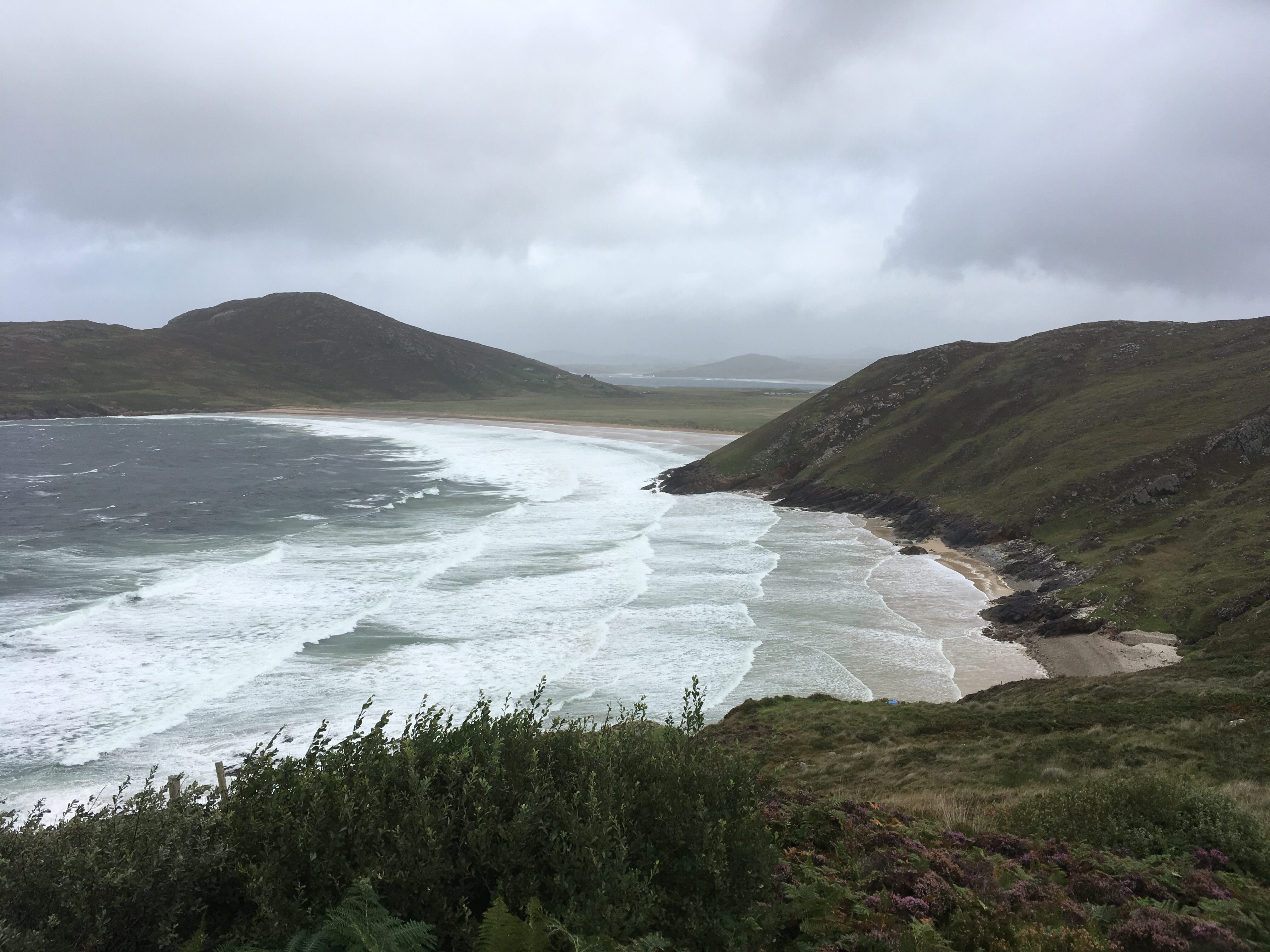
A short walk of 10 to 15 minutes across a field to the left leads to the spectacular Boyeeghter Bay, location of the beach known as the Murder Hole. No signs, no path. While dangerous in severe weather conditions, it is a magnificent spot with views of Horn Head and Tory Island.

The Murder Hole with Horn Head and Tory Island on the horizon. (Image Sara Nylund)

There is a bit of a slope down to the strand that obviously has to be climbed up again on the way out, but it is well worth the effort.

A slope down to be navigated at the Murder Hole (Image Sara Nylund)

The efforts will be rewarded with spectacular views of this special place.

The Murder Hole Beach. You need to keep a close eye on the tide! (Image S.Nylund)

The more adventurous may like to walk up to the World War 2 Look Out Post and to the EIRE sign, placed to warn WW2 Pilots that they were approaching neutral Ireland, but they were also useful navigational aids.

The Melmore Head sign (Image Eirmarkings.org)

The walk back to the road is very nice too, with Melmore Lough tucked under the hill. The entire area is designated a Special Area of Conservation for the protection of flora and fauna and as such, must be treated with respect, and also when crossing a private working farm to access the beach, take care to close gates etc.

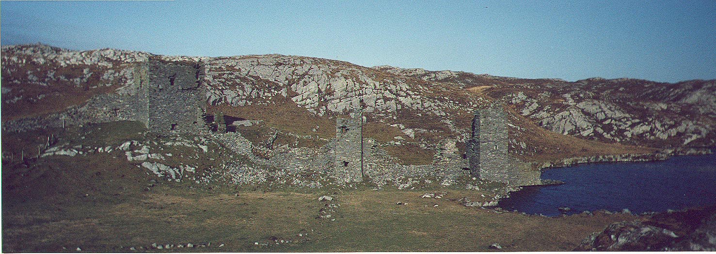
Back at the Caravan Park is Melmore Beach. This beach struck terror into us as children as it was absolutely forbidden to go near the water’s edge because of dangerous currents. That said, we often enjoyed Sunday picnics here under strict supervision. It was a matter of awe to us that if you listened carefully you could hear stones and rocks rolling about under the water. In the distance is Melmore Point, the most northerly point on the peninsula and accessible only on foot. I walked out to it many years ago, up past the ruins of a Napoleonic Signal Tower towards the spectacular views of the surrounding coast.

Looking towards Melmore Point from above Melmore Beach (Image the silvervoice)
Melmore Beach(Image thesilvervoice)
Looking across at the Fanad Peninsula opposite Melmore Beach (Image theilvervoice)

Retrurning to the main road again, there are beautiful sandy beaches to your left along the entrance to Mulroy Bay. The Narrows is the name given to the narrow inlet into Mulroy Bay.

Past the Youth Hostel and to the left is The Mass Rock. This cross was erected about 1910 by Mrs Phillimore of the nearby residence, so that the people of the area could pray here instead of having to undertake the two hour walk to the Catholic Church in Umlagh. Canon Gavigan, the parish priest of the time refused to bless it and very sadly, it was never used for the purpose for which it was intended. It now stands as a monument to the hardship these people had to endure.

Returning to the R258 and turning left, there are fabulous views of Melmore and Mulroy Bay, allowing you to see where you have been! A fabulous look into your rear view mirror!

Note – *A ‘dander’ is a local word meaning a stroll or leisurely walk.

References

Mevagh Down The Years by Leslie W Lucas. Volturna Press 1972.

4 Comments

Filed under Ireland, Wild Atlantic Way

Postcards from the Wild Atlantic Way – Mizen Peninsula Co Cork

We left East Cork on a wet and miserable Sunday morning, heading to West Cork with its wonderful scenery. The weather cleared. The sun shone.  It was a perfect day for drifting along the coast enjoying the moments. Here was the Wild Atlantic Way in all its glory! After a wonderful breakfast in Budds of Ballydehob, we headed to Barley Cove to stretch our legs. The magnificent beachscape here and sand dunes were created by a tsunami in the aftermath of the great Lisbon earthquake in the 18th Century.

Next stop was Mizen Head itself with its rugged landscape, pointing out into the Atlantic Ocean at Ireland’s most south-westerly point. The visitor centre here forms the entrance to the Mizen Signal Station, built on an island in 1905. Access is via a very secure walkway and bridges with a number of easier walks to viewing platforms. Everywhere you look the cliff scenery is spectacular

The walkways allow for close encounters with birdlife and a close-up view of some spectacular geology.

It takes about 10 minutes to walk down – longer to walk back up via the famous 99 steps!

The signal station with keepers quarters was severely damaged in the storms of last winter and they and the Marconi Radio Room were still under repair at the time of our visit. All the more time for us to enjoy the fantastic views of Dunlough Bay and out towards Sheeps’ Head and the Beara Peninsula. Afterwards, we meandered towards Three Castle Head. Access to the site is via a working farm, unsuitable for our dogs, unfortunately, but we enjoyed the lovely countryside.

  • This is what we missed – next time, hopefully!

    Dunloughcastle_4.jpg

    Three Castless overlooking Doulough – Image Wikipedia.

    We then headed towards Crookhaven via Browhead with its interesting fieldscapes. Traces of 19th Century copper mines remain here.

    From the pier in Crookhaven…an old quarry works can be seen.

  • We headed back via the famous church in the townland of Altar. This Church of Ireland building was erected between 1847 and 1852, at the behest of  Rev. William Fisher, who gave work to the poor people of the area, with funding from Famine Relief. He named it ‘Teampol-na-mbocht’  – the Irish for Church of the Poor.

    Nearby is a fine example of a Wedge Tomb

  • It was a beautiful end to a beautiful day, overlooking Toormoore Bay.

6 Comments

Filed under Ireland, Wild Atlantic Way

Postcards from Rosguill Peninsula Co. Donegal

Rosguill is a peninsula in north Donegal pointing out into the Atlantic Ocean, to the west of the well known Inishowen and Fanad Peninsulas. It is on the Wild Atlantic Way and has scenery to rival anywhere in Ireland. It is also in my home parish of Mevagh and any trip home is not complete without a jaunt along the Atlantic Drive.

Carrigart Co Donegal (Image Donegal Cottage Holidays)

Our village of Carrigart lies at the entrance to the peninsula and it was from here that I headed out last week and I hope you enjoy these few snaps from my phone.


Carrigart village is on the shores of the sheltered Mulroy Bay overlooked by Gainne a high hill across the shore. The Carrigart restaurant is under new management and offers a very interesting menu for travellers and a very comforting log fire!

Leaving the village of Carrigart we head towards the neighbouring village of Downings crossing the area known locally as the Lee. Years ago horse racing was held here and it was a great venue for young boys playing soccer. This stone bridge, Ballyhogan Bridge,  used to be an iron bridge and we children were subjected to awful warnings from adults about the particular part of a stream that flowed under it, known as ‘The Black Hole’.

The Atlantic Drive Road. This is a loop, but I like to drive it in the other direction via Downings.

Downings, on Sheephaven Bay, has a couple of hotels and a number of restaurants. as well as the famous McNutts weavers.  Once it was a very busy herring fishing port. Its maritime history is acknowledged near the pier with a memorial to locals who drowned in the area, including the three little McCorkell children who drowned in 1921 when herding geese and they were cut off by the tide. The inscription belies the fact that their little bodies were not all recovered immediately. Their father William recovered 5 year old Elizabeth at Aughadahor  on March 22nd;  7 year old Jane was found by Edward Shiels on Downings Beach on March 29th and Willie aged 3, was found washed up on Downings Beach by Cornelius Boyce on April 7th. What a terrible tragedy for the family who lived in Aughadahor, which is on the upper end of nearby Tramore Beach.


Also at Downings Pier is a gun from the  SS Laurentic, an armed merchant cruiser that sank after hitting two mines off Fanad Head on January 25, 1917 with the loss of 354 lives.  The gun was salvaged by the Downings Diving group. These memorials are my first stopping-off point as I like to remember that the sea in all its majesty, also claims lives.

Heading on, there is some spectacular scenery to the left out over Sheephaven Bay, looking towards the Ards Peninsula and Marble Hill strand with Muckish in the background. Sheephaven Bay lies between the Rosguill Peninsula and Horn Head.  Stopping places are limited but there are some viewing points along the way.  At Dooey, the little beach slopes dramatically and depending on the weather and tides it may be accessible, but is not safe for swimming.

Dooey

A few hundred metres further along there is a magnificent viewing point with views of Horn Head, back towards Dooey, and Tory Island, just about visible to the right of Horn Head, and the wild Atlantic Ocean.


In spite of the strong wind blowing on the day of my visit, the sea looked relatively calm. a large swell was expected the following day.

Here is one of my favourite views. This abandoned house was once the home of a salt working family. The 1st edition Ordinance Survey map (produced in the first half of the 19th century) shows the little cobbled beach as ‘Salt Pans’ where salt was extracted from the sea water

A short distance away is  probably one of the most spectacular views in Ireland.

The famous postcard pair of beaches at Tranarossan.

The next photo of Tranarossan was taken last year on a very misty day when the sea was very calm. Tranarossan has so many moods..it is different at every visit!

image1

Just above Tranarossan Bay it is possible to see some hard won little fields, in all probability fertilized with sea weed to turn the rough scrub into lush green fields.


I often think that I would not mind living in this sheltered little valley with this spectacular backdrop!

Driving up the hill, a breathtaking view opens out ahead. This is the entrance to Mulroy Bay, where the Atlantic rushes in between the Rosguill and Fanad Peninsulas.

Mulroy Bay is a very scenic stretch of water.  A bridge now connects the two peninsulas

The  ancient graveyard and church ruins of Mevagh, from which the parish takes its name,  are located here at the water’s edge. Here too is an  ancient early christian cross.


The Ancient Mevagh Cross

On a clearer very calm day some years ago I was able to take these pictures.

The ‘back isles’ on Mulroy Bay from near the boatyard

View from Carrigart village towards Island Roy

At the end of the Atlantic Drive, Tramore beach comes into view again.

Looking towards Tramore Beach across the famous Rosapenna Golf Links


The  Atlantic Drive, only a few miles long, is to my mind, one of the most spectacular routes anywhere in Ireland.

There are two professional landscape photographers in the area, if you would like to see  stunning images from this beautiful part of Donegal and across the county, click on the links below!

Scenes of Donegal

Rita Wilson Photography


10 Comments

Filed under Ireland, Wild Atlantic Way

Postcards from a special Kilmacrennan tea house!

Every once in a while you stumble on a little treasure of a place and want to tell the world! Such was our experience last Sunday afternoon in the village of Kilmacrennan in North Donegal, Ireland.

 On a day filled with torrential downpours we were in need of some comforting food, and so we stopped at the very pretty group of thatched cottages on the Creeslough end of the village. This group of little thatched buildings have been in Kilmacrennan for some 150 years and previously housed a museum.

They are now under the management of a young couple who have exciting plans for these lovely buildings.

If you fancy a B &B in an authentic thatched Irish cottage, this is the place for you! This beautiful cottage is available to rent on Air B and B.

The former little dairy will be used for workshops.

The largest building houses a tea and coffee shop, and when you step inside you know you have arrived somewhere special! It’s not just a matter of tea or coffee, it’s so much more! Wonderful food, wonderful atmosphere and a warm welcome await!


The light lunch we enjoyed was very special with artisan breads and very creative choices of savoury and sweet options served in beautiful surroundings.

The centre piece is of course the open fire with a blazing turf fire and a crane with a selection of cooking pots that were used in times gone by.


We were just a little too early for the music sessions that happens here on a Sunday afternoon but there was a lovely atmosphere even without it! 

It’s great to see new ventures and people thinking outside to box to provide unique high quality services to locals and visitors alike. I heartily recommend a visit to this lovely place, for either breakfast, lunch or a coffee break …you will not be disappointed! 


A gem of a place! 

Coffee Time Cafe Facebook page is at https://www.facebook.com/tiscoffeetime/

Twitter account is @tiscoffeetime

7 Comments

Filed under Irish Cooking, Irish Countryside, Irish Heritage

Discovering landmarks and Family History on Blacksod Bay, County Mayo

Continuing along Ireland’s Wild Atlantic Way, rain and low grey cloud were my only companions as I headed into this remote Irish-speaking part of County Mayo. Although visibility was reduced it was still possible to enjoy some lovely sights. The Irish-only road signs were something of a challenge at first, even though I am used to our bilingual signs here in Ireland and Irish-only signs in Donegal, and other Gaeltacht areas, these places were not familiar to me. However, once I figured out that ‘An Fod Dubh’ meant ‘Blacksod’ and that therefore ‘Chuan and Fhóid Duibh’ was Blacksod Bay, I chugged along happily in the beautiful Mullet Peninsula that protects Blacksod Bay from the worst of the Atlantic weather.

img_7597

Trá Oilí or Elly Beach

This eye catching beach is one of many big sandy beaches in the area. It sports the Blue Flag, one of the world’s most recognised eco-labels, indicating that it complies with a specific set of criteria on water quality, information points, environmental education, safety and beach management. Raining or not, this is a good beach for swimming!

Tír Sáile – the North Mayo Sculpture Trail –is the largest public arts project ever undertaken in Ireland.  Several of these sites are located here on the Mullet peninsula. This work is entitled ‘Deirbhile’s Twist’ and I like that it was formed by raising large granite boulders already lying around on the ground and arranging them into an eye catching feature. This is located at Falmore which is a beautiful location, even in the mist!

Saint Deirbhile (Dervilla) is a local saint who arrived at Falmore in the 6th Century. Arriving by donkey she was pursued by an unwanted suitor who,so the story goes, was very attracted to her beautiful eyes. Rather drastically she plucked them out to discourage him and he left, heartbroken. Water gushed from the spot where her eyes fell and after bathing her sockets her sight was restored. The ruins of her convent are here near the seashore with Deirbhile’s Well nearby. Modern day pilgrims believe that water from the well can help cure eye complaints and they come here for special devotion on August 15 each year.

Ruins of Dervilla's Monastery

Ruins of Dervilla’s Convent

And then on to the site I was particularly interested in – Blacksod weather station, situated at the end of the peninsula.

This is Blacksod Lighthouse, looking very unlike a traditional lighthouse, perched atop an old granite building that dates from 1864. This is a very significant place because it was from here that a weather report issued on 3rd June 1944 changed the course of history. The World War 2 D-Day landings scheduled for June 5th were delayed because of the hourly weather report lodged by Irish Coast Guardsman and lighthouse keeper Ted Sweeney, which indicated that there would be adverse conditions in the English Channel for the following few days. Blacksod was of particular significance because it was the first land-based observation station in Europe where weather readings could be professionally taken on the prevailing European Atlantic westerly weather systems. Ted’s report on June 3rd mentioned a rapidly falling barometer and strong winds which would have augured badly for the planned invasion. A further report from Ted at 12pm on June 4, said ‘heavy rain and drizzle cleared, cloud at 900 feet and visibility on land and sea very clear’. This meant that better weather was on the way for the south of England, and so Operation Overlord went ahead on June 6th 1944 with calm clear conditions in the English Channel.

img_0938

Plaque at Blacksod Lighthouse

There is a nice little harbour alongside the lighthouse, Termon Pier, which was almost totally deserted when I was there with only rain and wind to be heard and seen and a few currachs pulled up out of the water.

Winds were picking up the rain was relentless so it was time to leave. I was delighted that I had made the trip out here and discovered a few sights, in spite of the conditions.  Suddenly there was an incredible noise that almost deafened me and for the life of me I could not figure out what on earth it was.  On turning round I saw a helicopter had just taken off from right beside me, as  there is a Helicopter Landing base beside the Lighthouse!

A helicopter lifts off

A helicopter lifts off.

I left here very pleased with my foray into this area, and with the few treasures I had discovered. However, the Mullet Peninsula had one more surprise in store as not far along the road I  came upon Ionad Naomh Deirbhile, a local Visitor and Heritage Centre.

img_1292Although they were about to close I was invited in for tea and a homemade scone and here discovered the story of The Tuke Fund assisted emigrants. It is not always recognized that hunger in Ireland did not end with the famines of 1845- 1852 and 1879. Hunger and deprivation were a fact of life in poorer districts of the western seaboard in particular, with hundreds of families needing relief into the mid 1880s and beyond. James Hack Tuke (1819-1896) was an English Quaker who made it his mission to aid people suffering from starvation and deprivation in the West of Ireland. One of the features of the Tuke Fund assisted migration was that only entire families would be facilitated, thereby freeing up smallholdings for another family. The emigrants were provided with the fare and money to enable them settle in their new locations.  In 1883 and 1884, 3,300 emigrants left North West Mayo and Achill, boarding ships in Blacksod Bay.  They sailed on 10 separate voyages, for Boston and Quebec. There are impressive storyboards at the centre, where descendants of those who left here almost 140 years ago are welcomed. One such family arrived while I was there. It is reckoned that over 2 million people are descended from these North Mayo emigrants

The research on the Blacksod Tuke Emigration scheme was carried out by Rosemarie Geraghty, I believe for her thesis. Rosemarie has researched the 10 ships manifests that carried these families to their new lives in what she describes as the time of the  ‘forgotten famine’  and is absolutely delighted when descendants arrive here in search of their roots. I asked her what the charges are for family research and she said ‘They left here with nothing, we are never going to charge them to know where they came from.’ Rosemarie is ably assisted by Norah Cawley, a superb scone maker who makes visitors feel very welcome indeed. I have been to many a family research centre before, but never one like this – with such enthusiasm, warmth,  passion  and great scone making!

All of this information with family names  is available free to view, and is searchable under various headings, at http://www.blacksodbayemigration.ie . They just love to hear from anyone wherever in the world whose ancestors may have left this beautiful place over 130 years ago.

On what was a miserable wet grey cloudy day, how lucky was I to discover such wonderful silver linings at the Mullet Peninsula and on the shores of Blacksod Bay!  More treasures of the Wild Atlantic Way – Beidh mé arais arís!


St Deirbhile Stained Glass window at the Centre.

St Deirbhile Stained Glass window at the Centre.

References

http://www.independent.ie/irish-news/how-blacksod-lighthouse-changed-the-course-of-the-second-world-war-30319681.html

http://www.blacksodbayemigration.ie/

http://www.museumsofmayo.com/deirbhile.htm


12 Comments

Filed under Emigration from Ireland, Family History, Ireland, Ireland and the World, Irish Countryside, Irish Diaspora, Irish History, Mayo Emigrants

Landslide! Pullathomas Co. Mayo.

Visiting the uniquely interesting Ceide Fields was a damp experience and as I left there heading west on my trip along the Wild Atlantic Way in June of this year, conditions became even wetter, with persistent view-blocking rain. It was disappointing to be in this beautiful area for the first time in inclement weather but I saw enough to be sufficiently captivated to resolve to return again….sooner rather than later.

image

The rain was lashing down..

As I drove along with Sruwaddacon Bay to my right, windscreen wipers at full tilt, I came across a very ‘odd looking’ graveyard on the side of the hill. I pulled up to investigate and couldn’t quite make out why this place did not look ‘quite right’ for want of a better term.

Something didn't look 'quite right'

Something didn’t look ‘quite right’

I was quite amazed then to discover that this beautifully situated graveyard had suffered after very heavy rain some years ago when a landslide send thousands of tons of mud down the hill and carried coffins into the sea, never to be recovered. This catastrophic event took place in  September 2003 and the signs of it are clearly visible today.

image

The catastrophic landslide was blamed on overgrazing by sheep as the heather and upland plants were no longer able to bind the peaty soil together. The torrential downpours came after a particularly dry summer and the hillside was turned into mud that slid down the hill into the sea. I cannot begin to imagine what it must have been like for families whose graves had vanished under the tons of mud.

image

A plaque commemorates the awful event in 2003

There are three distinct sections to the graveyard at this site, but only the one in the foreground was affected by the landslide.

imageSteps have now been taken to make sure that there will be no repeat of this awful event,with  barriers installed to hold back any further soil slippage.

image

The location is quite beautiful, with the seashore only feet away.

This graveyard is also known as Kilcommon graveyard or  Pollatomish graveyard. There is an excellent website here that has details of those buried there and, unusually, includes people for whom there are no headstones.

Had it not been pouring rain, I may not have noticed this site as I drove by.  A beautiful place for sure, one that reminds us of the power of nature which we should never underestimate.


Further reading:

http://goldenlangan.com/graves-pt.html

11 Comments

Filed under Ireland

Seamus Heaney’s Flaggy Shore

image Seamus Heaney was one of Ireland’s best loved poets. His death came suddenly on August 30, 2013, leaving an entire nation bereaved. While his work and his words live on in bookshelves and on bedside tables across the land, he is greatly missed. He had such a way with words and such a mellow speaking voice that I for one could listen to him all day long.
imageOn my recent trip along the Wild Atlantic Way I happened upon The Flaggy Shore in County Clare on the shores of Galway Bay. So here in front of me was a seascape that inspired this great man. On a grey day the leaden sky hung over a silvery sea lapping a silvery grey shore. I could not help but wonder how such a scene could inspire anyone!  And therein is his greatness. I recall reading that Heaney said of his poem about the Flaggy Shore ‘we drove on into this glorious exultation of air and sea and swans.’ The swans were not on the lake beside the shore on the day of my visit but there certainly was an abundance of air and sea!

Perhaps it takes a man of Heaney’s caliber and talent to see such beauty in what could be considered a relatively mundane landscape! Many know of this poem as ‘The Flaggy Shore’ but the correct title is ‘Postscript’.

image

Postscript

And some time make the time to drive out west

Into County Clare, along the Flaggy Shore,
In September or October, when the wind
And the light are working off each other
So that the ocean on one side is wild
With foam and glitter, and inland among stones
The surface of a slate-grey lake is lit
By the earthed lightening of flock of swans,
Their feathers roughed and ruffling, white on white

Their fully-grown headstrong-looking heads
Tucked or cresting or busy underwater.
Useless to think you’ll park or capture it

More thoroughly. You are neither here nor there,
A hurry through which known and strange things pass
As big soft buffetings come at the car sideways
And catch the heart off guard and blow it open. – Seamus Heaney
image

Seamus Heaney, poet, playwright, translator and lecturer, and the recipient of the 1995 Nobel Prize in Literature passed by this Flaggy Shore before me. I am so glad he did. He died three years ago. His legacy lives on.

10 Comments

Filed under Ireland, Ireland and the World, Irish Countryside, Irish Culture, Poetry

The Céide Fields: The World’s oldest known field system

A Pine tree that lived in Mayo 4,300 years ago

A Pine tree that grew in Mayo 4,300 years ago and lay preserved in bogland.

In Ireland we have an annual celebration of our Heritage during National Heritage Week, part of the European-wide ‘European Heritage Days’, that promote every aspect of our wonderful, varied heritage. During this week there are hundreds of events showcasing the richness that we have inherited in our natural surroundings, our landscape our buildings and in our literature, history legends, and culture. This is an excellent time to make new discoveries and to revisit favourite places.

This year I will mark Heritage Week by recalling my visit just a few weeks ago to one of the most unique landscapes anywhere in the world that is to be found in North County Mayo, along Ireland’s Wild Atlantic Way. This place is called The Céide Fields, (pronounced Kay-Ja), a one thousand hectare monument that is the world’s largest dated Stone Age or Neolithic site. 5,500 years ago, a farming community lived, loved and worked here, raised their children, reared cattle, made pottery, grew crops, built homes, made gardens and buried their dead.

Blanket bog protects the site

At first sight, there appears to be very little here on this barren landscape –  all the more bleak on the morning of my visit with strong wind and driving rain! The land that stretches up over the hill seems to be flat and featureless, and will be recognized by Irish people as ‘just bog’. Bog is an emotive type of wetland landscape here in Ireland.  For centuries peat bog has provided fuel for our homes  and in recent times efforts to conserve some of this type of endangered habitat have become politically charged and confrontational. But here near Ballycastle in Mayo, this very landscape has protected a way of life for thousands of years, covering features of times past with metre after metre of protective vegetation.

In Ireland we have two types of peat bogland covering 1/6th of our land mass – smaller scale ‘Raised bogs’ which are the subject of conservation restrictions, and the more ubiquitous ‘blanket bogs’ found in much of the West of Ireland and here at the Céide Fields. These wetlands have evolved over aeons as can be seen in the diagram below demonstrating the evolution of blanket bog from the past, when the land was farmed; bog formed and enveloped the area; then peat removal for fuel resulted in the ground being used for growing again.

image

Peat is formed from dead plants that have not fully decomposed due to the lack of oxygen in very wet soil. Sphagnum which has water retention properties is a key component of bogland as it keeps oxygen levels low and steadily the dead plant matter of the sphagnum accumulates. The bog can grow to many metres in depth as the vegetation keeps building up. Here at the Céide Fields, the blanket bog covered over the remnants of the prehistoric farms to a considerable depth, smothering trees and other vegetation that once grew there.

The bog covered and concealed evidence of early life.

The bog covered, concealed and protected evidence of early life

In this representation of a turf bank below, it can be seen that over the centuries the depth of the bog increase. Today where is 1.5 metres high; 2,000 years ago, at the time of Christ, it was 0.9 metres high; 4,000 years ago at the time of the Egyptian pyramids it was 0.3 metres deep and a thousand years earlier people lived and worked in this fertile area.

A model of a turf bank showing evidence of turf cutting

A model of a turf bank showing evidence of turf cutting

This remarkable landscape was first noticed by a local man in the 1930s when he was cutting turf for his home fire. He noticed piles of stones as he cut deeper into the turfbank and felt that they were so orderly that they must have been placed there deliberately by humans. Years later his son, Séamus Caulfield an archaeologist, conducted  an investigation and discovered the series of walls, houses and tombs deep below the bog. The site has now been extensively explored and excavated to a limited degree, enough to show that the community of farmers who lived here 200 generations ago had reclaimed their ground by clearing vast expanses of pine forest. Seeds and pollen found at the site have been identified and dated and this with other dating methods has enabled scientists to determine the age of the site, the type of crops grown and the implements used.

Reconstruction of a plough used by these ancient farmers

Reconstruction of a plough used by these ancient farmers

There is a splendid award winning interpretive centre here, with guided walks available. There is a wealth of flora and fauna at this site unique to the habitat.  Unfortunately on the day of my visit inclement weather prevented such exploration, but by studying  the excellent exhibits I was able to et a great understanding of the treasure that is here.

Céide Fields Award Winning Interpretive Centre

Céide Fields Award Winning Interpretive Centre

The centre has a viewing platform that on better days than this, affords fabulous 360 degree views of the entire area.

The steps to the viewing platforms.

The steps to the viewing platforms.

In spite of the inclement weather I did venture outside on to the viewing area and was very happy to have a rail to hang on to in the very blustery wind and driving rain!


Steps leading to the Heart of the Céide Fields.

Steps leading to the heart of the Céide Fields, from where the guided tours begin.

It was a real thrill to finally visit this incredible site with an extraordinary and unique history. Irish Heritage at its best!


References

http://www.heritageweek.ie

Irish Peatland Conservation Council. http://www.ipcc.ie/

The graphic on the evolution of bogland is from the website http://www.irelandstory.com, which at time of writing is no longer available.

Céide Fields


8 Comments

Filed under Ireland, Irish Countryside, Irish Heritage

Postcards from the Wild Atlantic Way:Easkey County Sligo

Continue reading

1 Comment

Filed under Ireland, Irish Countryside, Irish Culture, Irish Heritage, Irish History

Postcards from the Wild Atlantic Way: Glencolmcille- a place apart

imageTucked away at the end of a valley in south Donegal is the unique and beautiful little village of Glencolmcille. It is easily missed by the tourist as the village is on a spur road that leads only to Glencolmcille. Apart from the scenic location, the village is renowned for the wealth of archaeological evidence of settlement dating from 3,000 B.C, a strong musical tradition, as well as being a haven of peace and tranquility.
The road into the village gives an idea of the remoteness of the village. I love these wild rugged empty spaces.

Then you see it way below where the land meets the sea…

Glencolmcille at the end of the valley

Glencolmcille at the edge of the sea

image

The village is tucked under Glen Head with its Martello Tower and the church dominates the village

The world famous feature of Glencolmcille is ‘An Clachán’ cluster of replica buildings that depict life over about three centuries. This museum development was the brainchild of the local priest, James McDyer who spearheaded a campaign for the development of small community based industries and tourism  in a bid to stop the constant migration from the area. When he arrived in the area in 1951 there were no proper roads, no electricity service and no water supply. He was the champion of Glencolmcille and indeed a thorn in the side of officialdom as he relentlessly sought to improve the lot of the people in this deprived area.

Among the clusters of small buildings are a school, a grocery shop as well as a number of typical houses of times gone by. My favourite has to be the school as it so closely resembles the school I first attended in the 1950s at the age of 3, complete with slates for learning to write.

Outside there is a replica Sweat House..I am not sure of the purpose of this, possibly to cure ailments?

A Sweat House

A Sweat House

I loved the collections in the houses, all telling if times that were, long before the advent of electricity, when families had to be self sufficient.

Beds were usually placed near the fire for warmth.

The kitchen dresser held all the China and sugar bowls and jugs

And we had similar washstands to these, these were in use before running water became available.

There’s so much to see and to do at Glencolmcille, it is easy to see why people return time after time. For now though, I have to keep heading south along the Wild Atlantic Way, but I leave here promising that I will return one day.


2 Comments

Filed under Ireland, Irish Countryside, Irish Culture, Irish Heritage, Living in Ireland