Category Archives: My Travels

Postcards from the Irish National Stud

IMG_3932Ireland enjoys a worldwide reputation for producing top class thoroughbred horses that consistently achieve international success. The largest producer of thoroughbreds in Europe, Ireland ranks as the fourth largest in the world. This success is attributed to our temperate climate and calcium-rich soil that is good for young animals. It has long been on my ‘to do’ list to visit the Irish National Stud in Kildare and I finally managed to tick this box the other week. What a treat it was on a beautiful sunny day!

The Irish National Stud and Gardens belongs to the people of Ireland. Established in 1900 by Colonel William Hill Walker, a wealthy and somewhat eccentric Scotsman who bought 1,000 acres in Tully Co Kildare to establish a stud farm.

4401A8C7-806B-47AC-AAFE-06C5041CFF2FThis statue of Colonel Walker, unveiled by President Higgins in 2015, portrays him looking at the items in the tree of life that interested him. In addition to racing, we can see signs of the zodiac which informed much of his horse breeding. He was also interested in gambling as indicated by the playing cards!

E96EE547-52BB-4DF4-8692-A4A2952F8883Col. Walker also loved horticulture and it was under his direction that the world famous Japanese Gardens were created here between 1906 and 1910, by the Japanese Craftsman, Tassa Eida.

Having enjoyed some success in racing circles, including winning the prestigious Epsom Derby, Walker gifted his stud farm to the British Government in 1915, to form the basis of the British National Stud. Their success continued with the stud producing the winners of all classics and in 1942, Sun Chariot, born and bred at Tully, landed the fillies’ Triple Crown – the 1,000 Guineas, Oaks and St. Leger – for King George VI. However, in 1946, the by now independent Irish Republic took over the ownership and running of the redesignated Irish National Stud. Although the acreage of the stud has now been reduced by about a hundred acres because of road building, this place continues to produce top class bloodstock that makes their mark the world over. Many famous racehorses are retired here, excellent stallions stand here and foals are bred here.

Of the retired horses, or ‘Living Legends’ as they are known, even I as a non-racing person, recognized many of the names.


This lovely fellow is Hurricane Fly, trained by Willie Mullins. He is the holder of the world record for most Grade 1 races won by any racehorse. His paddock mate is Hardy Eustace, a very famous 21-year-old.

In the paddock are another three retired ‘living legends’, including Beef or Salmon, seen below on the right. Beef or Salmon was trained in Limerick by Michael Hourigan. Also here are Kicking King and Rite of Passage. These are world-class racehorses, living out their retirement in luxury on buttercup filled meadows!  Until his death a few years ago, the world-famous Vintage Crop grazed here too –  he was the 1993 winner of the Melbourne Cup – the first foreign-trained horse to do so.  All of the ‘living legends’ are geldings and are people friendly lovers of sugar cubes. (Unlike the stallions that would attack)

IMG_3942

In a paddock nearby are some of the new season foals standing with their mothers. All foals have a birthday of January 1st, regardless of when they are born. This determines the categories of races they may enter.

In addition to the Japanese Gardens, the grounds are beautifully enhanced by St. Fiachra’s Garden just opposite the paddocks of the retired famous boys. These gardens were looking great at the time of my visit and are delightful for walking and are formed on a reclaimed wetland.

Here too are some reconstructed Beehive huts similar to those found in Kerry.

But it is hard to beat nature in all her glory!

IMG_3953

This route leads to the area where the Stallions are kept. Potentially very dangerous animals, they are contained between two layers of fencing.

IMG_3959

Invincible Spirit in his buttercup rich paddock

Meet Invincible Spirit – he is grazing there in his meadow the background. This is the current king of the National Stud whose offspring can sell for millions. With stud fees of €120,000  a session, he is kept busy and covers many mares, making him the highest earner hereabouts, providing 80% of the total annual income of the stud.

IMG_3971

The stabling is ‘high end’ as these horses are living in the lap of luxury with this yard named after the famous Sun Chariot.

And so to the Museum. I was thrilled to bits to find Arkle here – although it was only his skeleton. Arkle was a remarkable racehorse, a real legend, one of the greatest racehorses that ever lived, one that we were familiar with in the 1960s and one that had a personal impact on our house. My younger sister Eva recalls someone coming to look for her one day when she was about 8 or 9.  We children tended to roam about and wander from house to house in the village, coming home only when we were hungry about mealtime. She was eventually located and told that our father wanted her at home immediately. She hesitated thinking she was in trouble of some sort, but when she reluctantly arrived at the house she was informed that she had won a white Bush Television in a draw because she had chosen Arkle as her horse, who had gone on to win whatever the race was. And here was the wonderful Arkle, the main exhibit in the museum, who provided us with a TV when they were something of a rarity in our neck of the woods.

IMG_3966

The skeleton of the legendary Arkle – he supposedly loved to drink Guinness.

Not only did Ireland introduce Steeplechasing to the world, but we see in the museum that we also introduced showjumping – the first showjumping competition in the world was held in Dublin in 1868. In 1937 Ireland became the first country to have three successive wins and win the 2nd Aga Khan Trophy outright  In 1937. (Switzerland had previously won the 1st trophy outright by winning three times, but not successively) .

IMG_3967

The Aga Khan Trophy

This jockey weighing -in chair was interesting and very ornate!

IMG_3968

The visit to the National Stud was fascinating and so very worthwhile! Absolutely educational and in such wonderful surroundings.

Our father was ‘mad’ about horses and often drove about the country with my young daughter ‘looking; for horses in fields. They were often seen up on ditches peering at them or hanging over farm gates admiring them. He never put a bet on a horse in his life, but he loved them and passed that on to my daughter who became an accomplished rider, showjumper and dressage contestant. I am not sure if Dad ever got to the National Stud, but today on Father’s Day, I dedicate this post to him. He would love it. So would you!

8 Comments

Filed under Ireland, Irish Culture, Irish Heritage, Living in Ireland, My Travels

Postcards from London: Walking on the dead of Whitechapel.

With a passion for Family History, I spend a considerable amount of time in graveyards and cemeteries. Many friends with similar interests are often perplexed to hear of burial grounds where it is proposed to  ‘lawn over’ or reuse graves. This challenges deeply held beliefs in many cultures about burials, mainly to do with dignity and respect. Although we have a number of really old and now closed graveyards in Ireland (that double as quite unique wildlife and natural habitats), we sometimes have burial grounds uncovered during development. We also have ‘reconfigured’ gravesites such as those at Ireland’s best-known necropolis, Glasnevin in Dublin. They refer to some of these as ‘gone over graves’, where a plot, already occupied, comes up for sale.

The was a recent exhumation of over 60,000 remains in St James’s Park in Camden to make way for London’s new High-Speed Rail System – See here.  The recreational park under which they have rested for almost 150 years boasted a tennis court as part of the amenity. In all probability, we must be walking and playing on the graves of the millions of dead who inhabited the earth for aeons before us. Yet we don’t often come face to face with this reality. I did, on a recent trip to London.

Whitechapel

It is always great to return to the east end area of London, where I worked once upon a time. The Whitechapel Road runs into Aldgate, one of the historic entrances to the City of London. This is Jack the Ripper territory and although most of the little lanes and the smog are long gone, one’s step does quicken when walking through this area after dark! On the night of my arrival, I made my way from the underground station to the apartment of my friend, taking a shortcut through a graveyard. It was a little disconcerting to see groups of young lads in behind a tomb, presumably trading or partaking of something illicit, so I sped along. I returned the following morning to see what had become of this graveyard as it had changed quite a bit from the place I remembered.

FACDB1DC-4111-426A-A67F-A592F749669F

Altab Ali Park – spot the tomb!

Formerly known as St Mary’s Park, this is now Altab Ali Park with an interesting history. It occupies a very historic site on the Whitechapel Road, itself following the line of the ancient Roman road between London and Colchester.

58FB8F34-BAC1-4F35-B873-483178C091BD

Entrance to Altab Ali Park

The church that stood here has had many iterations.

The first was a chapel of ease, built between 1250 and 1286. Constructed using a white chalk rubble, the area becoming known as Whitechapel, a name that has been in use since 1344.

Wrecked by a storm, it was rebuilt in 1362, thanks in no small measure to a Papal Bull negotiated by the absentee rector  – Sir David Gower, then a Canon of St Patrick’s Cathedral in Dublin – that promised remission of sins for pilgrims who parted with their money on visiting the church.

Known as St. Mary Matfelon, it stood until 1763 when it was demolished and replaced by a red brick church.

st-mary-matfelon-whitechapel-1830.jpg

St. Mary Matfelon 19th century  (Image  London Illustrated News)

It was found to be structurally unsound in the later part of the 19th century and was reconstructed between 1875 and 1878.

Whitechapel-High-Street-1937-St-Marys-Church-jack-the-ripper-7893581-365-480.jpg

St. Mary’s c. 1878 (Image Wikimedia Commons) Note the Drinking Fountain!

Unfortunately, it was then destroyed by fire just a few years later in 1880.

Whitechapel_St._Mary's_Church_after_the_fire_1880 (1)

After the fire (Image Wikimedia Commons)

It was rebuilt again in 1882 and stood here into the 20th century until Seriously damaged by bombing on December 29, 1940.  When the remains were struck by lightning in 1952 it was finally demolished shortly afterwards.

St-Mary-Matfelon-9-5-1941-HELR-F238-768x586.jpg

The bombed shell of St Mary’s (Image Wikimedia Commons)

The site was used as park thereafter. During an archaeological dig by the Museum of London in 2012, remains of the original buildings were found and the park was reviatlized . It now includes a raised walkway outlining the footprint of the earlier churches, with some sections of the original masonry on view.

BE713988-74E6-408C-B5E6-0676D3873373

The path follows an outline of  one of the original churches


E9C08324-7089-45E9-8A49-6F12D6A2C59B

Fragments of the original structures alongside the paved area marking the footprint of the church.

The area is now grassed over, but what of the burials that took place here down the ages?  Unlike St James Park mentioned above, there were no reinternments. The graveyard is the last resting place for some notable men, such as Richard Brandon, the alleged executioner of King Charles 1, who died in 1649, and Sir John Cass, the educational philanthropist who died in 1718. There was a rather gruesome discovery in the church belfry in 1863 when 11 coffins and skulls of many children were discovered during repair works. It was surmised that the coffins may have been dropped through the belfry roof by families unable to afford the cost of a grave, but wanting the remains to repose in a Christian site.  In the following year, there was a further gruesome discovery when a ‘pile of bones’ was discovered in one corner of the graveyard. Newspaper reports stated that there were at least 18 bodies and that they were ‘shockingly mutilated’. Nothing seems to have come of the investigations into this and the conclusion was that these remains had been stored in a bone house.

In common with other graveyards in London, St Mary’s became very overcrowded and by the mid 19th-century burials ceased. The Gentleman’s Magazine noted in December 1850 that “St Mary is setting an excellent example to the Metropolitan parishes whose churchyards will soon be closed under the Internments Act. It was planted with trees and shrubs as it was a known fact that trees absorb and convert noxious gasses given off by the process of decomposition of the body.

The graveyard has now been cleared of headstones which have been ‘tidied’ to the perimeter.

The tomb of the Maddock Family, timber merchants, who lived here in the early 19th century is a prominent feature of the park and serves as a ‘hangout’ for socializing youths.

790E1E3D-D0E7-4171-8619-3CE7E937F064

The Maddock Chest Tomb

And so, St Mary’s has now become Altab Ali Park, a strange name for a landmark in London. It was renamed in memory of a 25-year-old Bengali textile worker who was murdered by three teenage racists on May 4, 1978, as he made his way home from work. At that time racial tensions were running high especially in London’s east end, which had attracted a lot of Pakistani immigrants. The thugs who murdered him, spurred on by the vicious racism of the National Front, said they did it because he ‘was a Paki’.  From the tragedy has come some good- the park is the first public space to be named for an immigrant and every year in May the Altab Ali Commemoration takes place in this historic place.


20570E81-39FB-4C71-8922-3E3CB0FD17E7.jpegIn one corner of the park is the Shahid Minar, representing a mother protecting her children with the red sun behind. The Shahid Minar is also referred to as Martyr’s Monument. It has deep cultural and historical significance for Bengalis as it commemorates five Bengali students shot dead on 21 February 1952 in a demonstration in support of the right to use the Bengali language within Pakistan.

Altab Ali Park has had an interesting history down the centuries. Scores of individuals pass through here each hour, most of them unaware of what lies beneath their feet.

Set into the exterior wall by the entrance is my most favourite feature of all. It is the drinking fountain which has witnessed many changes. Although relocated, I love that it is seen almost exactly as it is today, in the image of the church of St Mary’s c.1878 above.


4E8D4499-27C7-49FF-94F2-2802D0D3C7AE

The Pink Marble Drinking Fountain dates from 1860. A good resting place for a bicycle.

Sources/Further Reading

The history of this site is contained on information boards at the perimeter.

SurveyofLondon.org

British Newspaper Archives

http://www.towerhamlets.gov.uk


10 Comments

Filed under Ireland, My Travels

Postcards from Ballybeg Priory, Buttevant, Co Cork

img_4885For years I  have been travelling the torturous route between Limerick and Cork, the N20, surely one of Ireland’s worst major routes with single file traffic wending its way along through towns and villages, with serious sharp bends to be negotiated.

Perched alongside this road, on the Cork side of the town of Buttevant is the fantastic Ballybeg Priory. As many motorist do, I have been taking side glances at this ruin for decades as it is far too dangerous and impossible to stop on the main road.  Before you know it, you have gone past the narrow access road.  However on my last foray on the notorious N20,  I was determined to pull over to take a look at this ancient place and so I finally managed to turn off into the access laneway.

Founded in 1229 for priests who lived a monastic life, the Canons Regular of St Augustine, the Priory was laid out with buildings surrounding a central courtyard or  cloister. Two fine windows of the original church were incorporated as part of a tower some centuries later.

img_4868

Much of the site is inaccessible as there seem to be some works being undertaken by the OPW.  It’s an awful pity that they do not provide notices as to what the are doing or why sections are barricaded. Their non medieval porta-cabin does nothing to enhance the visitor experience.

img_4880

Cabins and barriers but no explnataion.

Not withstanding these 21st century intrusions, this is a very special place with a wonderful mystical atmosphere. It is sobering to think that I have walked where monks did as long ago as 800 years back.

This site also has a pigeon house, or columbarium, with roosts for about 350 birds and is considered to be the finest of its kind in all of Ireland. It was not possible to get any closer on the day of my visit.

This dove-cot provided food for the monks and also fertilizer for their farm.  An internal view of the dovecot can be seen here.

It is well worth stopping here to explore this ancient site. It’s a pity that not all of the site is accessible, but hopefully that will improve when  the OPW finish their works.

img_4888


Further reading

http://www.buttevant.ie/History/Ballybeg-Abbey.html

http://irishhistorypodcast.ie/ballybeg-priory-co-cork/


1 Comment

Filed under Ireland, Irish Countryside, Irish Culture, Irish Heritage, My Travels

Postcards from the Wild Atlantic Way: Feeling ‘The Force’ at Malin Head

Inishowen in County Donegal is Ireland’s largest peninsula and includes Ireland’s most northerly point at Malin Head. Prior to the marketing of the Wild Atlantic Way, the ‘Inishowen 100’ was a well-known tourist route that took in much of the beautiful scenery of the area.

image

My first port of call on the peninsula was at Dunree Head, the site of a former British Fort that guarded the strategically important deep anchorage of Lough Swilly.

image

Looking across Lough Swilly towards the Fanad Peninsula.

Lough Swilly has witnessed many major historic events. It was from Rathmullan on the Fanad Shore that O’Neill and O’ Donnell fled into exile, in what was known as The Flight Of the Earls in 1607, following the defeat of the Irish chieftains by the British at the Battle Of Kinsale

In 1798 Wolfe Tone was taken under naval arrest to Buncrana port and it was near this spot that a small fort was built at Dunree to guard against a possible French invasion.

The fort was expanded in the late 19th century and during World War 1 it stood guard over Admiral Lord Jellicoe’s fleet that lay at anchor in the deep Swilly waters prior to engaging the German Navy at the Battle of Jutland. Even after Irish Independence, the British maintained a presence here up to just before World War II.

Onward then to see some of Inishowen’s lovely coastline, although visibility was not great and heavy rain was promised so it was a race against the elements to see as much as possible. There are beautiful beaches at almost every turn, not always safe for swimming as there are powerful currents running here. Here too at Lagg are some of the highest sand dunes in Europe.

Just a couple of weeks before I visited there was great excitement at Malin Head when the Star Wars film crew arrived to film some scenes for a new series. The excitement continues as dozens of Star Wars devotees undertake a pilgrimage to the area.

Malin Head is known throughout Ireland and Great Britain as Malin is a sea-area for maritime shipping forecasts. There is a weather station here, often recording Storm Force 12 winds in winter. There was barely a breeze when I visited which was rather disappointing, so I had to sit on a stone and imagine the Star Wars Force surrounding me instead! The actual most northerly point is named Banba’s Crown. Here too are a watchtower dating from the Napelonic Wars in 1805 and a 1902 Signal Station. Banba’s Crown is well known nowadays too as a site for spectacular Aurora Borealis sightings in the dark unpolluted skies at Malin Head.

There are interesting geological features along the coast.

I loved this little pebbly beach along the roadside and I enjoyed watching the parents of these ducklings steering their brood through the water! At this point the heavens opened and much of the beautiful seascapes disappeared into the mist. image

I was delighted to happen on this memorial to Young Irelander,Thomas D’Arcy McGee a native of Carlingford, Co Louth who, charged with treason after the failed 1848 rebellion, made his escape to the USA from this dangerous coastline. He went on to be known as the father of Canadian Confederation. Ironically he was assassinated by Fenians in 1868.

Tremone Bay

Tremone Bay

I finally arrived on the eastern coastline of Inishowen, where the small towns of Moville and Greencastle sit on the shores of Lough Foyle. Moville was a point of embarkation to Canada and USA for thousands of emigrants  in the second half of the 19th Century. The little fishing village of Greencastle is home to a Fishing Museum with some interesting artefacts from days gone by, and it has a very nice tea rooms!

As I leave Inishowen, there was a compulsory stop to be made at the Grianan of Aileach,a series of forts that stand 800 feet above sea level. Dating from 1,700 BC, Grianan of Aileach  features on a 2nd Century map of the world.

On a clear day the views from here are stunning and even on a not so clear day it was an appropriate spot to have a last view lovely Lough Swilly.

image

7 Comments

Filed under Ireland, Irish Countryside, Irish Culture, Irish Heritage, My Travels

Postcards from the Wild Atlantic Way – Fabulous Fanad

Fanad is a peninsula in north Donegal in the northwest of Ireland, lying between the peninsulas of Inishowen and Rosguill, the latter of which is ‘home’ to me. It is where I was brought up, made friends, was schooled and where my family rest. We had many cousins in the Fanad peninsula, just a short drive away. This is where our paternal grandmother was born and grew up. I never knew her, but I did know her extended family, her nieces and nephews. It is always wonderful to return to Fanad; a trip ‘home’ is never complete without a visit to Fanad, first to our grandmother’s grave and then on to Fanad Head and back along the scenic Glenalla Road with spectacular views of Lough Swilly.

A bridge links Rosguill and Fanad peninsulas

A bridge links Rosguill and Fanad peninsulas

In recent years a new bridge across the Mulroy has been opened between the Rosguill and Fanad peninsulas. It is my personal belief that by using the bridge and not driving along Mulroy Bay visitors miss out on much of the beauty of the area. A trip along the Mulroy Loop is well worth the extra short drive of about 30 minutes of beautiful scenery.

Kindrum . This is a memorial to Fanad men who assassinated the tyrannical landlord, the 3rd Earl of Leitrim

Kindrum. This is a memorial to Fanad men who assassinated the tyrannical landlord, the 3rd Earl of Leitrim, in 1878.

Just a few minutes away on the shores of Mulroy Bay is Massmount Church and graveyard. Immediately inside the gate is our family grave, and a visit here was always the starting point for Fanad visits.

My grandmother and great grandparents are in the grave seen here to the right. My grandmother's sister, my great aunt is in the grave behind and slightly to the left with the white headstone.

The Celtic Cross on the right beside the shrub is the headstone on the grave of our great grandparents,our grandmother and her sister and brother. Another sister rests in the grave behind and slightly to the left with the white headstone.

The tranquil waters of Mulroy Bay reflect the mood of the weather.

Further along the road and easily missed is a field with some markers where unidentified bodies are buried. Many of them were casualties of  war, washed up along this wild coast over the years. It would be nice to see some sort of simple memorial to them.

image

Graves of the unknown, washed up on Fanad shores.

And so it happens. You round a corner and up a hill, and there it is before you – Fanad  Head lighthouse, looking magnificent even on the dullest of days.

Fanad Head - The first glimpse

Fanad Head – The first glimpse.

As with all key places along the Wild Atlantic Way, there is a sign to confirm that you have arrived!

Fanad Head Lighthouse

Fanad Head Lighthouse. First  lit in March 1817

It is billed as one of the world’s most beautiful lighthouses. That’s as may be, but is has a very special place in my heart and that of my family. For many years the husband of my father’s first cousin was the Principal Keeper at Fanad Head and we enjoyed Sunday visits aplenty.

Fanad Head  Lighthouse has recently been opened to the public, so it was with a particularly joyous heart after a gap of about 50 years, that I made my way to buy my ticket and to once again climb the many steps to the top of the lighthouse.

It's a long way to the top

It’s a long way to the top!


But worth the climb!

But worth the climb!

While there was no smell of fuel  as I remember it, and the revolving huge lenses have been replaced by more modern technology, it was well worth the challenge to enjoy once again the fabulous if misty views out across Lough Swilly towards Malin Head and back towards Mulroy Bay. On a clearer day it would have been even more breathtaking!

There are interesting artifacts associated with the life of a lightkeeper and my favourite has to be this chest of books, supplied and regularly replenished  by Carnegie Libraries.

image
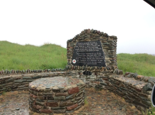
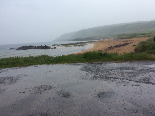
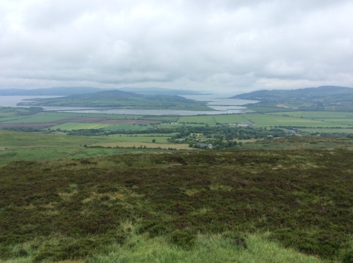
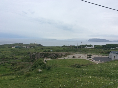
Heading away towards Portsalon I enjoyed a catch up with a cousin before taking the very spectacular Glenalla Road that runs along the cliffs and shores of Lough Swilly. At Ballymastoker Strand is a memorial to the crew of HMS Saldanha shipwrecked in a storm off Fanad Head on 4 December 1811 with 253 aboard. It is thought she went aground on rocks when attempting to make for shelter in Lough Swilly. There were no survivors and for weeks afterwards some 200 or so bodies were washed up on the strand. Some months later a bird was shot about 20 miles away and it turned out to be the ships parrot with a silver collar engraved ”Captain Packenham of His Majesty’s Ship Saldanha”. (Packenham was a brother in -law  to the Duke of Wellington of Waterloo fame). I wonder what happened to the collar!  As a direct result of the loss of the Saldanha plans were drawn up to build a lighthouse at Fanad Head, which was turned on in March 1817.

Dunree Fort guarded the deep safe anchorage of Lough Swilly up until 1938 when the British Navy left

Dunree Fort guarded the deep safe anchorage of Lough Swilly up until 1938 when the British Navy left

Rathmullan  was my next stop, with its beautiful sandy beach. An annual Regatta used be held here – and probably still is.

Rathmullan has a special place in the history of Ireland as it was from here that the Flight of the Earls took place in 1607. This marked a turning point in Irish history as the Chieftains of some of the leading Gaelic families of Ulster, including the O’Donnells and the O’Neills, left Ireland to seek refuge in Spain, following their defeat by the English at the Battle of Kinsale in 1601.  There is a fabulous sculpture by John Behan on the shorefront in Rathmullan commemorating the departure of the chieftains.  I just love it as it depicts loss, horror, pain and grief in a powerful way.

As evening approached the weather cleared up and I was sorely tempted to retrace my steps and to enjoy the scenery that was denied me by the mist over the past two days, but I had to head on, knowing that I would discover more wonders of the Wild Atlantic Way in Inishowen and that I will be back in fabulous Fanad!

During my 18 day trip I stayed in two particularly wonderful Bed & Breakfasts..of 5 star standard. One of these was Bunlin Bay House on Mulroy Bay – a perfect touring base for both the Fanad and Rosguill Peninsulas. Heartily recommended!


10 Comments

Filed under Ireland, Irish Countryside, Irish Heritage, Irish History, My Travels

Postcards from the Wild Atlantic Way – the mighty Slieve League Cliffs.

This is the 4th post from my almost 3,000 kilometer trip along Ireland’s Wild Atlantic Way. I have now crossed the border into my home county of Donegal in the north-west of Ireland. To my absolute shame, I had never visited one of Ireland’s premier attractions, the magnificent cliffs at Slieve League in the south west corner of the county. On the day of my visit, the car temperature gauge was showing 32 degrees C, almost unheard of in Ireland. It was also flat calm without a breeze high up there on the cliffs, which meant there was nothing ‘Wild’ about the Atlantic  below. For all that it was a most amazing experience to be up there on some of Europe’s highest cliffs, on the edge of the world. No commentary is needed on the photos, which I hope you will enjoy!


7 Comments

Filed under Ireland, Irish Heritage, My Travels

Postcards from the Wild Atlantic Way – Westport Co Mayo

At the beginning of June I headed off on a road trip of almost 3,000 kilometers mostly along the now world-famous Wild Atlantic Way. The Wild Atlantic Way is a touring route that runs along the north, west and south coasts of Ireland from Muff in Inishowen in County Donegal to Kinsale in County Cork. It has been a long-held dream to travel these coastal routes ages before it was branded the Wild Atlantic Way. I had two aims for this trip – to seek out the Wild Atlantic Way and to trace some family history.

My adventure began in Westport Co. Mayo, situated on Clew Bay on the west coast. I think I may well have been the only person in Ireland who had not visited Westport, one of our premier tourist towns that has recently been voted the best place to live in Ireland. Crammed with shops, restaurants, wonderful views and riverside walks, it truly is a wonderful place to visit. This was my first port of call as it was here that our grandfather was born, when his father-our  great grandfather worked at the local railway station. My visit was long overdue!

image

The town has several busy streets that converge at the octagon, where there is a statue of St Patrick high up on a plinth. I particularly like this statue of St Patrick as he is not in the usual 18th Century church regalia – and why should he be, given that he was about the place in the mid 5th Century!  Patrick was not always there however as the monument was originally raised in honour of a local man, George Clendenning (1770-1843). During the Irish civil war, the Irish Free State troops used the statue for target practice and the head was shot off. In 1990 Clendenning was replaced by St Patrick and this is a very handsome focal point  in the town.

Westport is the gateway to Croagh Patrick, a pilgrim mountain associated with St Patrick that attracts thousands of visitors each year.

imageI love this shot with the old-fashioned telephone box and the well populated sign post, while just across the road is this very colourful shop selling everything you might need for a really happy holiday!

image

The Carrowbeg River flows gently through the town, with lovely malls on either bank.

This is the very beautiful Church of Ireland church of the Holy Trinity which dates from about 1868. The intricate stone carving is the work of Charles Harrison and inside is a magnificent pulpit.

Just down the road is the mighty Reek, or Croagh (pronounced Croke) Patrick, rising 764 metres. Pilgrims of all ages make their way up the steep slope, often barefoot and not put off by weather. The annual pilgrimage takes place on Reek Sunday, which is on the last Sunday in July.

imageHere too is Ireland’s National Famine memorial, entitled ‘Coffin Ship’, a haunting bronze sculpture of a ship with skeletons as the rigging.

The Monument is at the base of Croagh Patrick and on the edge of Clew Bay

image

Further along the road is the very popular Old Head, a favourite bathing spot.

I enjoyed an evening walk along the shore at the ruins of the Murrisk Friary founded in 1457.

And later watched the sun set into the west on what was a fabulous first day along the Wild Atlantic Way!

image


6 Comments

Filed under Ireland, Irish Countryside, Irish Heritage, My Travels

Postcards from Cobh Co. Cork

Just about a 15 minute drive away is the fascinating town of Cobh, County Cork. It was known in earlier times as Queenstown, then as Cove. The spelling was then changed to the Irish Cobh (‘bh’ in Irish sounds like ‘V’), so pronunciation remained unchanged. This seaport on the southern coast of Ireland features large in the history of our nation. Sitting on what is one of the world’s finest natural harbours, Cobh has witnessed the emigration of millions of Irish whether by transportation to penal colonies, or in search of a better life in the New World. It is a poignant place, where so many of our people last stood on their home soil. My uncle was one of these who left for America from here and the sight of Cobh as they pulled out to sea stayed with him as a sad and tearful memory for decades.

Stark figures indeed!

Stark figures indeed!

Cobh has also figured large in maritime history. Nearby is Haulbowline the base for the Irish Navy and Spike Island with its 18th century star-shaped fort and a former prison.

The beautiful cathedral church of the Diocese of Cloyne stands over the town.

image

Designed by Pugin and opened in 1879, St Colman’s is on the site of the old Bridwell. This beautiful building dominates everything around. The spire was added to the structure later and completed in 1915. The largest Carillon  in Ireland and Britain comprising 49 bells is here and following restoration it is now considered one of the best in the world. Cast in Loughborough, England and weighing some 25 tons, the bronze bells were transported from Liverpool to Cobh by courtesy of the British Navy, as no civilian vessels could make such a delivery during World War 1. The bells are not rung with ropes but are played with a keyboard with pedals that move the clappers. I was here at 4 pm which is one of the times when the hour chimes are followed by a tune. It was quite an experience to hear them ring out over the harbour!

Cobh has very steep little lanes leading down to the water’s edge,with colourful houses and quite a nice assortment of buildings.

Way below the imposing spire at the water’s edge is a delightful park, known locally as The Prom. Restored and upgraded several times, it was constructed in 1805 and  renamed Kennedy Memorial Park in the 1980s. I am not sure what connection JFK had with the town.

Cobh famously was the last port of call for the ill-fated Titanic on her maiden voyage. The old White Star Line offices now house the Titanic Experience Exhibition. It was from here that the 3rd Class passengers embarked, while the 1st and 2nd class passengers embarked from the jetty at the old railway station.  Sadly the historic 3rd class pier has fallen into disrepair. (I have written posts on the TITANIC in the past, links to these are at the end of the post)

But Cobh is associated with another major maritime tragedy. On 7 May 1915, 101 years ago tomorrow, the Cunard liner RMS Lusitania sailing from New York to Liverpool was torpedoed by a German U Boat, off the County Cork coast with the loss of 1,198 lives. Although she sank within 18 minutes of being hit, 761 passengers survived. This incident is considered to be the catalyst for the entry of the USA into the war. In Cobh there is a fine monument commemorating the tragedy where many of the survivors and the dead came ashore.  The monument in the main street is directly in front of the building which was used as a morgue for the dead in 1915.

In the Kennedy Memorial Park there is a wall in remembrance of the survivors of the disaster.

194 of the Lusitania victims rest in three mass graves and 24 individual plots at the local cemetery. The mass graves contain 23 bodies, 52 bodies and 69 bodies respectively, with names of those buried there carved on 3 glass memorials.

These sad memorials are in the very historic graveyard that bears witness to a number of tragedies at sea, with many sailors resting here. It is worthy of a visit to experience some of the history and to marvel at some of the stonemasons craft.

image

The Republican Plot

Back in the town, one of the most famous sculptures is dedicated to Annie Moore and her brothers who sailed from Cobh to join their parents in New York. Annie was the first person to pass through Ellis Island.

Cobh is a town that has so much to offer that it would take a number of visits to cover it all. I am fortunate that it is almost in my backyard, so I will be there on a regular basis, to explore its beauty and other aspects of the fascinating history of the place.

Previous posts on the Titanic

A Mayo village devastated by the Titanic disaster.

April 11 1912. Titanic sails from Queenstown.

April 13 1912 Titanic sails in calm waters

April 14 1912. Iceberg Ahead! Goodbye all!

12 Comments

Filed under Emigration from Ireland, Ireland, Irish Diaspora, Irish Heritage, Irish History, Mayo Emigrants, My Travels, Titanic

Postcards from Bere Island, County Cork

A few weeks ago I was able to go back to Bere Island on a day trip. Bere Island is in Bantry Bay just a short distance offshore from the County Cork town of Castletownbere, and overlooks the deep water harbour of Berehaven.

image

A Pontoon seagull gazes across to Bere Island with its Martello Tower.


We caught Murphy’s Ferry at Pontoon that crosses  to the village of Rerrin. The crossing takes about 20 minutes and is very pleasant on a calm day such as this.


The Bere Islanders, who number about 200, are very friendly and welcome visitors to enjoy the beautiful scenery, to cycle, to walk, to fish, to watch birds and whales, to enjoy the beautiful wildflowers. The  wildflowers were pas their best as we headed into autumn, but I can assure you that you will never see anything like the fabulous linear wildflower meadows that line the roads here throughout the summer.

imageThere is a very rich archaeological heritage on the island, which is well signed.

Around the harbour at Rerrin there is safe anchorage here for some very attractive yachts.

On arrival, the tide was out. How about this as an example of excellence in recycling!

The purpose of the visit was to attend a talk in the Lecture Theatre on the very important role of Bere Island in various times of conflict from the Napoleonic Wars to World War 2 .

These delightful women had travelled over to the island from Durrus to hear the talk and took time to have a picnic lunch in the lovely sunshine.

While inside, the World War 1 building and former chapel, the speaker was having a chat with the early birds.

imageAfterwards there was time for a whistle-stop tour of the island, but only after some delicious chowder in the Lookout restaurant. I loved the very unusual barometer that was hanging on the wall.

At the end of the high season the roads are particularly quiet and attractive for walkers.

It’s not all plain sailing though as we discovered when we met some stubborn locals!

The island scenery is good for the soul!

And so back to Rerrin to catch the ferry back to the mainland

The tide had filled while we were away and the harbour looked totally different.


Summertime, and the livin’ is easy, Fish are jumpin’ …..

Such a beautiful evening, with water lapping softly

No roll-on, roll-off ferries here –  it’s a question of trusting in the guy directing as you reverse on….

It had been a couple of years since my last visit  and I have been blessed with great weather on each occasion. It makes you want to go back for sure, to this island sitting in the splendour of Bantry Bay.

15 Comments

Filed under Ireland, Irish Countryside, Irish Heritage, Irish History, Living in Ireland, My Travels

Postcards from Dingle on Ireland’s Wild Atlantic Way

Steep cliffs, crashing, foaming waves, sandy beaches, misty islands, craggy rocks –  the jewel in the crown of Ireland’s Wild Atlantic Way is without question the dramatic and breathtaking Slea Head Drive on the Dingle Peninsula,in County Kerry,in the south-west of Ireland. The Wild Atlantic Way, where the power and might of the Atlantic Ocean dashes against the west coast of Ireland, stretches some 2,500 kilometres along the Atlantic coast,from my own beloved Donegal in the north-west to the beautiful Kinsale Harbour on the south coast.

Places elevate  the heart, but Dingle makes an imprint on the soul

Places elevate the heart, but Dingle makes an imprint on the soul

These snaps were taken last week on a very joyful trip back to this extraordinarily special place.Gulls are a big feature of the peninsula!

The road snakes perilously along the cliff, even crossing a stream at one point,

Even on the calmest of days, the power of the sea is evident.

The Blasket Islands, uninhabited since the 1950s, lie off the tip of the peninsula

Huge Atlantic rollers wash onto the sandy beach of Coumeenoole Strand,that featured in David Lean’s 1970s film, Ryan’s Daughter.

No trees withstand the harsh Atlantic winds, but there is an abundance of flowers in miniature clinging to the cliffs and in the fields.


While the magical scenery of the Slea Head Drive is an unforgettable part of the Dingle Peninsula, there is so much more to see and do in this area, which is centred on the lovely fishing port of Dingle town. Renowned for its Irish musical culture and traditions and good food Dingle is one of the most loved parts of Ireland, a very special place,well worth a visit at any time of year!


16 Comments

Filed under Ireland, Irish Countryside, Irish Heritage, Irish Traditional Music, My Travels